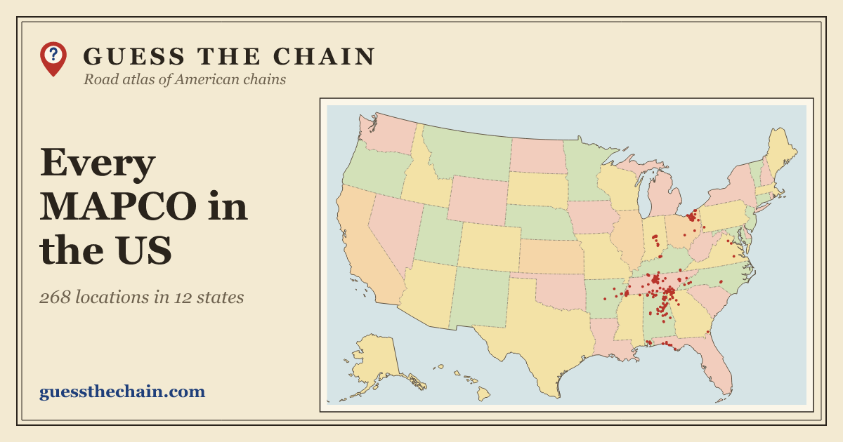
Map of MAPCO locations in the US
MAPCO has about 270 locations in the United States, spread across 12 states. The most are in Tennessee (109), Alabama (58) and Ohio (27). Per person, Tennessee has the most, with 1.5 locations for every 100,000 residents.

- Category
- Convenience & gas
- US locations
- about 270 (268 mapped)
- States
- 12
Where is MAPCO most common?
MAPCO is a regional chain: 72% of its locations are in Tennessee, Alabama and Ohio, which together have 7% of the population. Tennessee has 19 times as many per person as the US as a whole. It has no locations at all in California, the most populous state.
How many MAPCO locations are in each state?
| State | Locations | Per 100,000 people | Share |
|---|---|---|---|
| Tennessee | 109 | 1.5 | 40.7% |
| Alabama | 58 | 1.1 | 21.6% |
| Ohio | 27 | 0.2 | 10.1% |
| Georgia | 25 | 0.2 | 9.3% |
| Indiana | 11 | 0.2 | 4.1% |
| Florida | 10 | 0.04 | 3.7% |
| Kentucky | 8 | 0.2 | 3.0% |
| North Carolina | 8 | 0.07 | 3.0% |
| Arkansas | 5 | 0.2 | 1.9% |
| Mississippi | 3 | 0.1 | 1.1% |
| Virginia | 3 | 0.03 | 1.1% |
| Pennsylvania | 1 | 0.01 | 0.4% |
Which states have no MAPCO?
39 states have no MAPCO location in our data: Alaska, Arizona, California, Colorado, Connecticut, Delaware, District of Columbia, Hawaii, Idaho, Illinois, Iowa, Kansas, Louisiana, Maine, Maryland, Massachusetts, Michigan, Minnesota, Missouri, Montana, Nebraska, Nevada, New Hampshire, New Jersey, New Mexico, New York, North Dakota, Oklahoma, Oregon, Rhode Island, South Carolina, South Dakota, Texas, Utah, Vermont, Washington, West Virginia, Wisconsin and Wyoming.
Chains with a similar footprint
These chains are spread across the country in the most similar way:
- Captain D's 56% overlap
- Krystal 56% overlap
- Jack's 51% overlap
- Huddle House 50% overlap
- Logan's Roadhouse 48% overlap
- Zaxby's 45% overlap
More convenience & gas maps
Locations come from All the Places, which collects them from each chain's public store locator (data from October 2026). MAPCO's locator leaves some stores out, so 15 locations come from other sources (3 from OpenStreetMap (© OpenStreetMap contributors, ODbL), 11 from Foursquare Open Source Places (Apache 2.0, notice) and 1 from the USDA’s list of stores that accept SNAP (public domain)). Counts can be a little off: new stores open, old ones close, and a few locations may be missing. Population figures are Census Bureau estimates for 2024. Guess the Chain is not affiliated with MAPCO. Page updated November 13, 2026.